
下载App
资质规则
旅行
账户
JustPeachy3
Nice hike within a mile of the state capitol building
Ensign Peak Park的点评
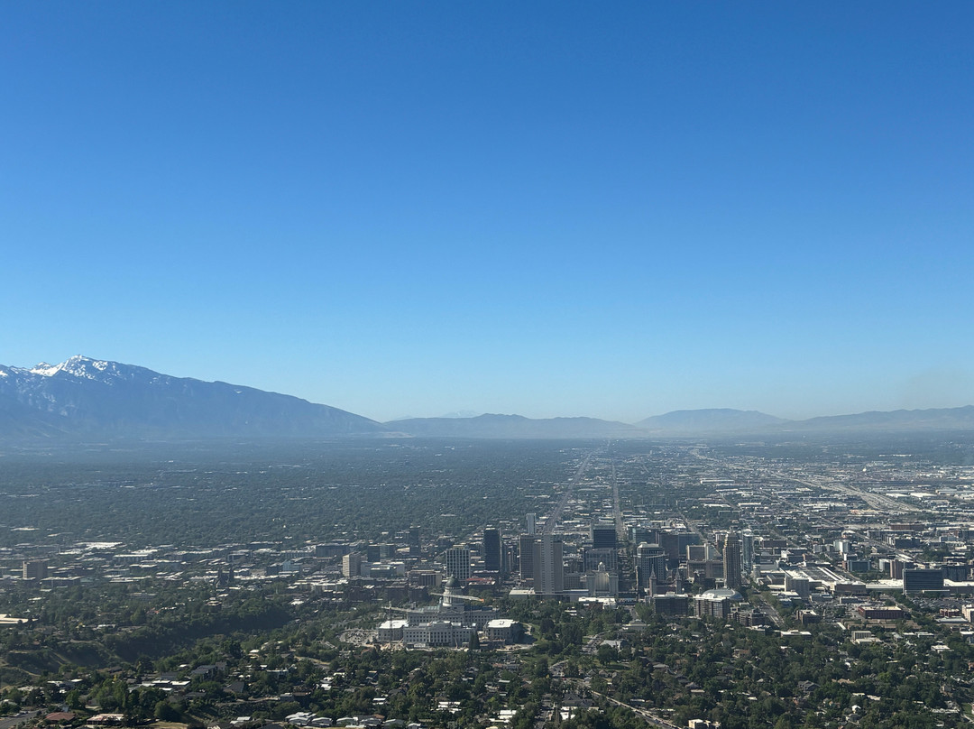
点评:Ensign Peak is a public park just north of Salt Lake City. It was here the Brigham Young laid out the rough plan for the new city, since the spot has a commanding view of the land between the mountains and the lake.
You park along the residential street adjacent to the park. I guess you could park a bit further away (near the capitol building, for instance) and walk further up too. Once you enter the park, there is a small level plaza with some plaques. You can ascend a few stairs and an incline (maybe you gain 25 - 30 feet in altitude) to the lower overlook. It is pretty close. Some of our party opted to wait there.
If you choose the hike to the top, it is around a mile and a quarter, I think (about 2 km). The trail is not paved, but is well worn. I don't know the exact altitude gain, but it is probably on the order of at least 250 feet, maybe somewhat more.
At the top there is a larger monument. You can see further to the south (than at the lower points) and you can even see the plaza and the street where you likely parked. I think it took us around 40 minutes up and back. It is easier if you have hiking boots (just to avoid slips on the descent) but I did it in sneakers.
If you want a moderate but short hike with great views, this is a good spot to check out.
翻译:恩士峰是盐湖城北边的一个公园。杨百翰正是在这里制定了新城的粗略规划,因为这里可以俯瞰群山与湖泊之间的景色。
你可以把车停在公园旁边的住宅区街道上。我想你也可以把车停得远一点(比如靠近州议会大厦),然后再步行上去。进入公园后,会看到一个小型的平坦广场,广场上有一些牌匾。你可以爬上几级台阶,再爬一段斜坡(海拔可能会上升25-30英尺),到达较低的观景台。那里离得挺近的。我们一行人中有些人选择在那里等着。
如果你选择徒步登顶,我想大约需要1.25英里(约2公里)。这条小路没有铺砌,但路面很平整。我不知道确切的海拔高度,但可能至少上升了250英尺,甚至更多。
山顶有一座更大的纪念碑。你可以看得更远(比低处更远),甚至可以看到广场和你可能停车的街道。我们上山下山大概花了40分钟。如果你穿登山靴会更容易些(只是为了避免下山时滑倒),但我穿的是运动鞋。
如果你想来一次中等强度但短途的徒步旅行,并欣赏美景,这里是个不错的选择。

© 2026 Tripadvisor 版权所有。
部分照片由 VFM Leonardo 提供。
TripAdvisor公司对外部网站的内容一概不负责。优惠价格中不含税和其他费用。
ICP证:沪B2-20200433
沪ICP备20013175号
 沪公网安备31010502005427号
鹰程信息技术(上海)有限公司